NOMADIC BORDER | LA FRONTERA NOMADA
  • Nomadic Border
    • Echoes from the Borderlands >
      • Battle of Ambos Nogales (Part I)
      • Battle of Ambos Nogales (Part II)
      • The Chicano Moratorium 50 Years Later
      • Monumental Border Mistakes: Boundary Monument 127
      • Mexico's Lost Archipelago >
        • Mexico's Claims to the Channel Islands
        • Brown Beret Occupation of Catalina Island
        • Catalina: Borderland at Sea
        • San Clemente Island: A "Voyage into the Heart of Darkness"?
        • San Miguel: Island of Many Kingdoms
    • Border Crossings
    • PHOTO ESSAYS
    • ABOUT ME
    • Terms of Use
  • La Frontera Nomada
    • EXPOSICIONES EN LINEA >
      • La Batalla del 27 de agosto entre los Ambos Nogales (Parte I)
      • La Batalla del 27 de agosto entre los Ambos Nogales (Parte 2)
      • El Archipielago Mexicano Perdido >
        • El Reclamo Mexicano Sobre el Archipiélago del Norte en California
    • FOTO GALERIAS
    • ACERCA DE MI
    • Condiciones de Uso

COMMENTS: Mexico’s Claims to its Lost Archipelago: The California Channel Islands

1/20/2020

10 Comments

 
The California Channel Islands located off the coast of the Greater Los Angeles area are today known for their rich ecological and recreational heritage, but were not  were not mentioned in Article V of the Treaty of Guadalupe Hidalgo (1848) which outlined the U.S.-Mexico border after Mexico surrendered California to the U.S. Indeed, a strict reading of the Treaty of Guadalupe Hidalgo suggested to many groups – indigenous Chumash people, White Americans, and Mexican people – that the islands were still Mexican national territory.
Picture
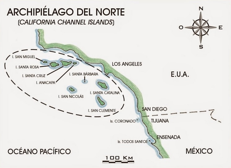
​Map by Víctor Busteros Angeles, “Día 23, jueves 5-05. Rumbo a Coronado,” Expedición al México de Ultramar (Feb. 13, 2015), (http://mexicodeultramar.blogspot.com/2015_02_13_archive.html).
Known as the “Archipelago of the North” when under Mexican rule, the potential for the lost Mexican islands not belonging to the U.S. raised many questions about the nature of the U.S.-Mexican border as a whole. Responding to citizen petitions, the Mexican President Manuel Ávila Camacho formed a government commission to study the case of Mexico’s lost archipelago. The so-called Ávila Camacho Commission (1944-1947) investigated historical Mexican rights to the Channel Islands but ultimately concluded that challenging the more powerful United States for the Archipelago’s return was unlikely to succeed politically or in international arbitration settings.
 
The ambiguity of the archipelago’ status in both the 1800s and 1900s encouraged various groups, including the native Chumash, White American ranchers, and Mexican American political activists to claim the islands for their own respective causes.
 
Whichever side one might sympathize with, the case of Mexico’s "lost archipelago" is a reminder of the complicated creation of the U.S.-Mexican border.
Read the story here
Picture
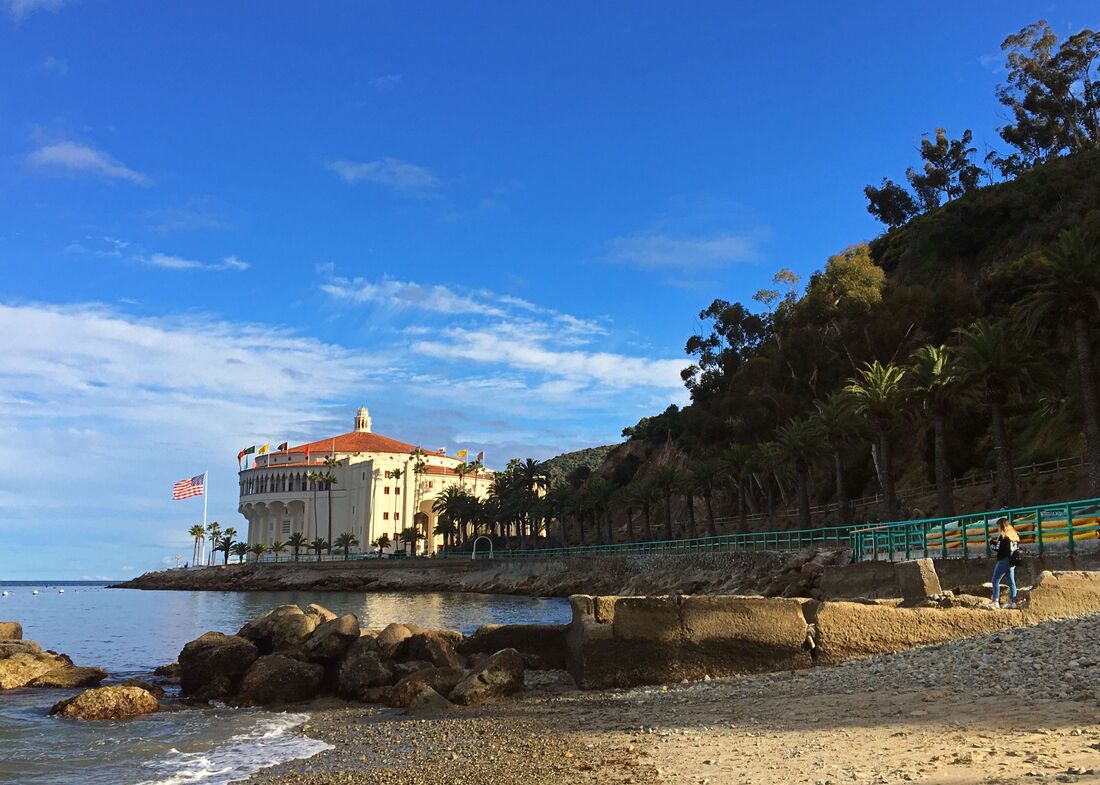
The Catalina Island Casino, the most famous building on California’s “Magical Island,” at one point did not allow Mexicans inside. Asserting Mexico never formally gave up the Channel Islands after the U.S.-Mexico War, in 1972 the Chicano Brown Berets occupied the hillside to the right of the Casino – “Campo Tecolote” – to bring attention to the discrimination faced by Mexican people in the U.S.
Picture
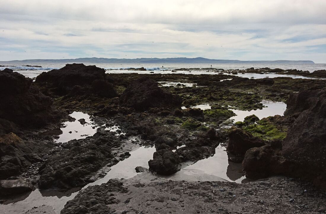
Pools near Frazier Point on the west end of Santa Cruz Island. Neighboring Santa Rosa Island is a few miles away. The Channel Islands are famous for the richness of their biodiversity on land and in surrounding waters.
Picture
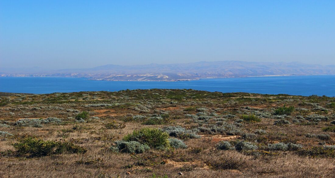
San Miguel Island, the westernmost of the islands in the U.S.-Mexican border’s Lost Archipelago of the North, is defined by its arid scrubland. Santa Rosa Island again comes into view to the east along San Miguel’s arid flatlands. Archaeological research has identified the Channel Islands as being the site of some of the earliest human remains in the Americas.
Picture
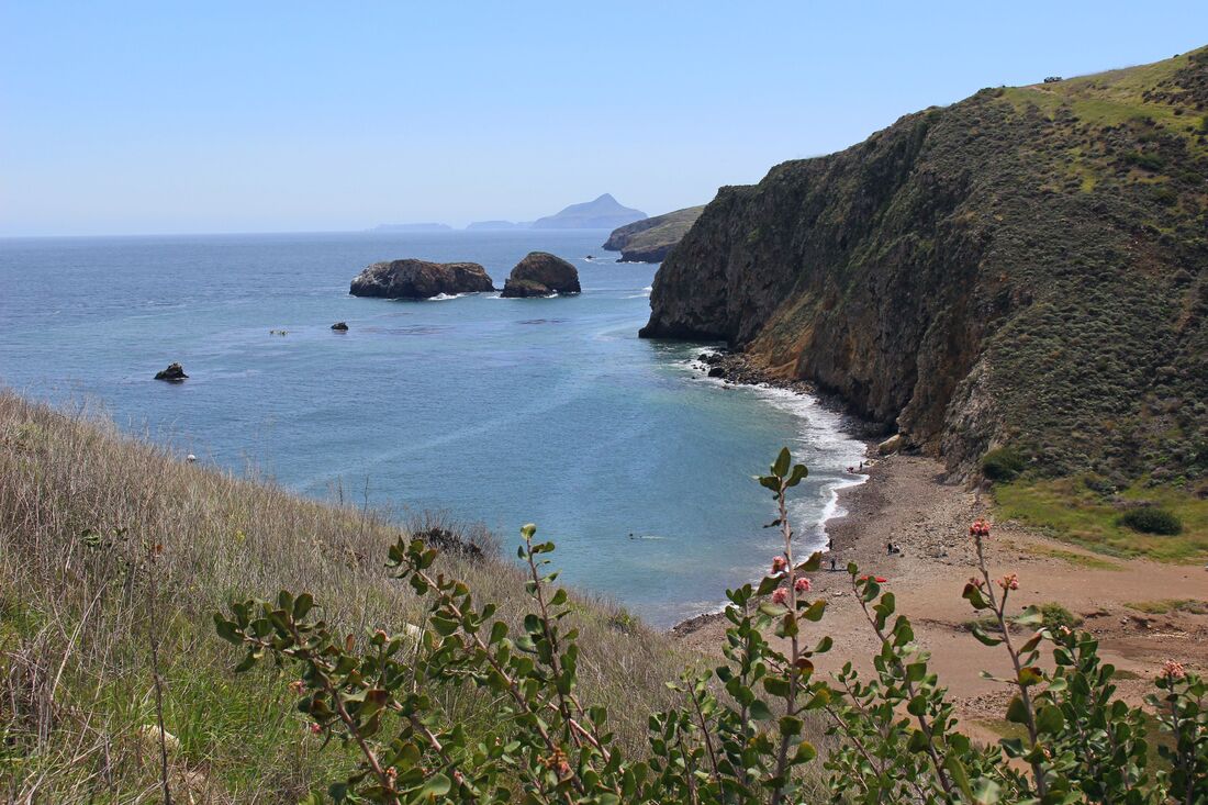
Scorpion Anchorage near the Channel Islands National Park visitor center on Santa Cruz Island. Anacapa Island can be seen in the distance.
Picture
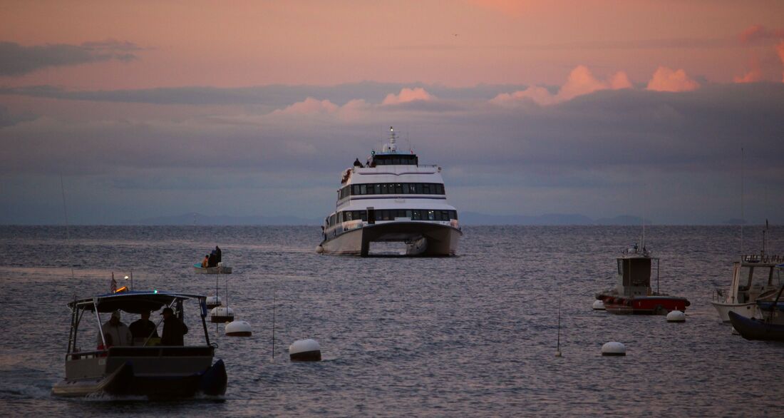
A ferry arrives in Catalina’s Avalon Bay at dusk.
Picture
Secretive San Clemente Island as seen from the Santa Catalina Island highlands.
Picture
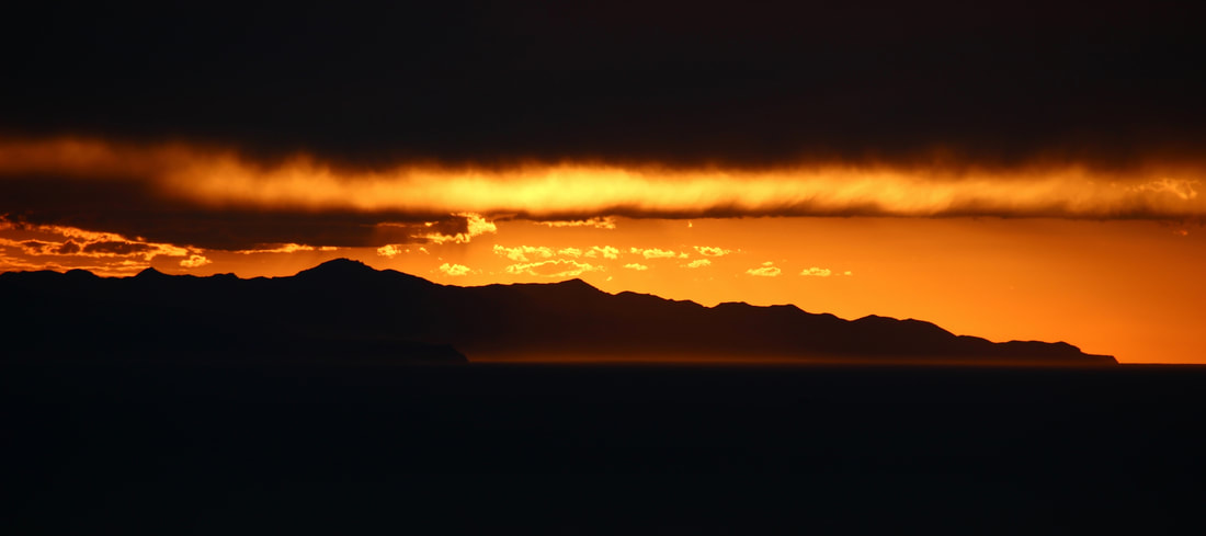
Santa Cruz Island, the largest island in Mexico’s “Lost Archipelago” and in the state of California, glows in the last moments of light.
Special thanks to Juan Menchaca and Gerald Joanino for their help in these cross-island adventures!
10 Comments
Sergio Maldonado
7/22/2020 13:55:05

What an amazing hidden piece of history. And the photos are quite beautiful!

Reply
Carlos Parra link
7/31/2020 21:49:38

Sergio,
Thank you for your comment. It's a tantalizing idea to think what might've happened if either the MX Gov't, the Chumash people, or the Brown Berets had made the Channel Islands' omission from the Treaty of Guadalupe Hidalgo into a stronger issue. These islands don't figure too prominently in our understandings of Latino or Native American histories - or even Southern California history for that matter.

Reply
Mike barriere link
9/12/2020 15:43:04

You have an interesting story here. But there are some various specific reasons why Mexico has no claim to the Channel Islands. Because of these primary legal precidents the case has zero merit in any juridiction.

Firstly, the US Military controls the Islands under a De Facto arrangement dating to before WW2. The US Navy operates both San Nicolas and San Clemente exclusively for defense purposes. Secondly and most definitively the Islands are County level possesions and were included in both the Spanish amd Mexican administrations as Real Property located in Santa Barbara and Los Angeles Counties. As Real Property subject to private ownership under both Spanish and Mexican Law, these lands are not subject to transfer of ownership just because of a Treaty. Families that had maintained land rights passed down deeds with specific property lines which are still defined.

Furthermore the Treaty of Guadalupe Hidalgo specifically ceded control of actual bored lands North and returning Tijuana to Mexico. Under the Conditions of Surrender signed at Mecixo City the US controlled Tijuana and the area of borderland back to Mexico. This effectively reverted the border from "line of actual control" back to the established County level boundaries already in place and currently recognized under Mexican Administrive Laws.

Santa Cruz Island is still divided into two properties and administered seperately. The Nature Conservancy Privately operates the Western half of Santa Cruz while the National Parks Ssrvice owns and Administers the other half. For these simple reasons no question of ownership status holds any merit in court.
There is the silent unspoken issue of highest best use principle. As a Nature Preserve all boaters are free to traverse the area and purchase landing permit for use. Restrictive use policies favor the environmental restoration efforts. We all know the Mexican Government could never be trusted with something as precious as these gems. As we all knoe the Mexican Centrak Government is amoung the most corrupt in the world. With zero oversight and a weak land use policy the Islands would immediately revert to despoiled farmland, ruining decades of hard work and over a million man hours.

To be fair the subject itself is laughable at best.

Reply
Carlos Parra link
9/18/2020 23:31:32

Mike,

Thank you for your detailed commentary on my borderlands history of the California Channel Islands. To be clear, I am not advocating for the Channel Islands being returned to Mexico, but the fact that there has been at least some level of ambiguity makes reconsidering their history from the vantage point of their being disputed territory a chance to revisit these islands' history from a perspective most books and area museums ignore.

Jorge A. Vargas's "El Archipiélago del Norte: ¿Territorio de México o de los Estados Unidos?" is the only book-length study of the matter from the Mexican perspective and he in fact shares your same argument that the Archipelago of the North was considered part of Mexican Alta California and thus naturally was transferred along with the rest of the state when the Treaty of Guadalupe Hidalgo was signed (1848). Although people at the time likely understood the islands as forming part of Mexico's territorial cession to the U.S., the Treaty specifically mentioned that the U.S.-Mexican border terminated at the Pacific coast south of San Diego - with many of the Channel Islands being significantly offshore (especially San Nicolas) there was merit to them not having become U.S. soil -at least initially (in the mid-1800s the concept of territorial waters didn't extend as far out from land as many of the outer Channel Islands.

Reply
Carlos Parra link
9/18/2020 23:59:36

Now regarding the issue of the privately-owned islands' legal status and concerns over their current-day resource management...

The Mexican land grants on Santa Cruz, Santa Rosa, and Santa Catalina - which I argue in my Catalina piece (http://www.nomadicborder.com/catalina-borderland-at-sea.html) played a large role in preventing them from becoming off-limits military reservations today - made the islands administrative dependencies of governments on the mainland (as you correctly point out, U.S. recognition of Mexican property thus meant the former Mexican landowners living in early American California (who were given U.S. citizenship in the Guadalupe Hidalgo Treaty) retained their ownership rights.

This question is at least worth discussing when it comes to San Nicolas, San Clemente, San Miguel, and Santa Barbara Islands which were not colonized or held as private property under Mexican law and which only hosted occasional fishermen, ranchers, and hunters without legal title to the islands. The U.S. government did not actively assert ownership of the outer islands until 1896 when it sent a surveying expedition to San Miguel when a Civil War veteran specifically cited the island's ambiguity under the Guadalupe Hidalgo Treaty to proclaim himself the King of San Miguel (http://www.nomadicborder.com/san-miguel-island-of-many-kingdoms.html). Of course, the U.S. Navy's control of the non-privately owned islands after the 1930s further strengthens the U.S. territorial claim to the Channel Islands.

Finally on your point on what environmental resource management would look like if the Archipelago of the North was still on Mexican soil...it's hard to say for sure since Mexico has a positive conservation record for its protected islands in the Pacific, such as with its Revillagigedo Islands which in 2017 became North America's largest marine protected area. That being said, conservation in areas closer to urban centers is much more mixed and often less successful. Would possessing 8 islands just off the Southern California coast be too tempting to not exploit? Or would they be like Revillagigedo, too far away from Mexican urban centers to be significantly developed? I agree with you though - the Channel Islands/Archipelago of the North are treasures and should be protected.

The fact we are having this conversation, in my view at least, makes this subject much more than something laughable - historical Mexican claims to the islands might not justify a change in their ownership, but they do make for interesting entry into a less-known aspect of the archipelago's human history.

Reply
Luna One
5/5/2021 16:25:22

Grusse! Would like to hear more about UFO sightings. Also , Where did you serve in Hawaii? That’s where I’m from.

Jesus
2/18/2021 10:38:37

Hola , my name is Jesus I was a marine that served in California amd Hawaii . We used to see UFOs around the area o see them for my self all over that location I have no evidence of the encounters have yiu done any research on the activity of UFOs in that area? Thank you

Reply
Carlos Parra link
3/4/2021 16:37:01

Saludos Jesus! Thank you for your service in the USMC. Where in California were you stationed? Do you mean that you have seen UFO activity near the Channel Islands? I have not read anything about that before - I would certainly love to talk to you more about that if you have the time. Thank you for your comment.

Reply
David Gunderson
8/9/2022 08:37:18

Interesting story! Appreciate your historical analysis. “The more you know…” 😉

Reply
Bertriana M.
10/3/2022 20:41:39

This was a very great read. I had no idea that this island even existed. Thank you for research in the history that you shared about the island and Mexico and California.

Reply


Leave a Reply.

    Carlos Parra

    U.S.-Mexican, Latino, and Border Historian

    Archives

    January 2021
    August 2020
    June 2020
    January 2020
    July 2019
    May 2019
    March 2019
    January 2019
    December 2018
    September 2018
    August 2018
    July 2018
    June 2018
    May 2018
    April 2018
    March 2018
    February 2018
    December 2017
    November 2017
    October 2017

    Categories

    All
    Ambos Nogales
    Arizona
    Baja California
    Border Art
    Border Fence
    Border Wall
    Border War
    Boundary Marker
    Boundary Monument
    Brownsville
    California
    Chicanos
    Chihuahua
    Chihuahuan Desert
    CILA
    Ciudad Juárez
    El Paso
    Heroica Nogales
    IBWC
    Identity
    International Bridge
    Juarez
    Los Angeles
    Matamoros
    Mexico
    Mojonera
    Monument
    Monumento Fronterizo
    New Mexico
    Nogales
    Nuevo Mexico
    Nuevo México
    Port Of Entry
    Rio Bravo Del Norte
    Rio Grande
    San Diego
    Sonora
    Sonoran Desert
    South Texas
    Tamaulipas
    Tecate
    Tejas
    Texas
    Tijuana
    Tucson
    U.S.

    RSS Feed

Copyright/Derechos Reservados © 2017-2023, NOMADIC BORDER | LA FRONTERA NOMADA
  • Nomadic Border
    • Echoes from the Borderlands >
      • Battle of Ambos Nogales (Part I)
      • Battle of Ambos Nogales (Part II)
      • The Chicano Moratorium 50 Years Later
      • Monumental Border Mistakes: Boundary Monument 127
      • Mexico's Lost Archipelago >
        • Mexico's Claims to the Channel Islands
        • Brown Beret Occupation of Catalina Island
        • Catalina: Borderland at Sea
        • San Clemente Island: A "Voyage into the Heart of Darkness"?
        • San Miguel: Island of Many Kingdoms
    • Border Crossings
    • PHOTO ESSAYS
    • ABOUT ME
    • Terms of Use
  • La Frontera Nomada
    • EXPOSICIONES EN LINEA >
      • La Batalla del 27 de agosto entre los Ambos Nogales (Parte I)
      • La Batalla del 27 de agosto entre los Ambos Nogales (Parte 2)
      • El Archipielago Mexicano Perdido >
        • El Reclamo Mexicano Sobre el Archipiélago del Norte en California
    • FOTO GALERIAS
    • ACERCA DE MI
    • Condiciones de Uso